 June 29, 2002
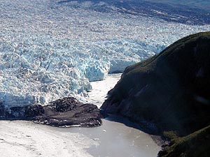
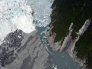
The constriction has slowed tidal influence in Russell Fiord enough that the fiord is now much like a lake. While water continues to flow out of the narrow gap to the sea, the freshwater runoff into Russell Lake is greater than the outflow into Disenchantment Bay. The US Geological Survey remote gauging station in the lake shows that the lake level has risen approximately half a foot per day since June 24, 2002. The Forest Service has convened a multidisciplinary team of specialists to implement monitoring strategies and reactivate resource monitoring sites in the impacted area; this team is proceeding on the assumption that closure of the glacier is imminent. The last time Hubbard Glacier closed the entrance to Russell Fiord was in late May, 1986. News media from around the world converged on Yakutat, Alaska, and covered this significant glaciological event. Between May 29 and October 7, 1986, runoff from a 695 square miles (1,800 square km) area of glaciated mountains raised the water level in Russell Lake to an elevation of 83 feet (25.3 m) above sea level. The lake rise inundated alluvial fans, outwash planes in front of several tributary glaciers, and, in places, the densely forested fringes of the former Russell Fiord. During late September and the first week of October, 1986, the ice dam narrowed due to calving into the lake and Disenchantment Bay. The dam began to break about midnight on October 7, 1986, and within 24 hours the water level had reached the former high-tide level of Russell Fiord. Should a stable ice dam form and the lake level rise to an elevation of about 131 (40 m), Russell Fiord could drain southward into the Situk River drainage, altering a world-class fishery, and inundating national forest and private land. The Situk River is a world-renowned steelhead and salmon stream and the most productive stream for its size in Alaska. It is a primary subsistence and commercial stream, and has a popular sport fishery with many lodges to support visitation. Because of the cultural, environmental and economic consequences of Russell Lake draining into the Situk River, citizens and officials of the community of Yakutat, as well as representatives of several State and Federal agencies, are showing keen interest and concern about the behavior of Hubbard Glacier. The Forest Service is taking the lead in the dissemination of information about this significant event; the US Geological Survey is providing research and technical expertise, and the ongoing monitoring is being supplied by an interagency team of Forest Service, National Park Service, and USGS representatives.
Related Story:
Source of News Release:
|
||